Mesoscale Convective Systems (MCS)
A mesoscale convective system (MCS) is a complex of thunderstorms that becomes organized on a scale larger than the individual thunderstorms but smaller than extratropicali cyclones, and normally persists for several hours or more.
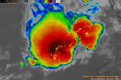
Picture 1. A great deal of lightning was associated with this MCS as it propagated eastward across the Gulf of Mexico, with the storm often producing over 1000 cloud-to-ground strikes within a 15-minute period.
Forms of MCS that develop within the tropics use either the Intertropical Convergence Zone (ITCZ) or monsoon troughs as a focus for their development, generally within the warm season between spring and fall.
Mesoscale convective systems (MCSs) are a key component in the Earth’s energy and hydrological cycles. They can grow to hundreds of kilometers in size, last for more than a day, and produce a majority of the annual rainfall in manyregions of the world. (C.D. Ahrens & R. Henson).
Picture 2. For the first time mesoscale convective systems (MCSs) in both the tropics and midlatitudes and all seasons can be tracked over many years by a new algorithm jointly using satellite observed cloud-top temperature and surface precipitation features at hourly and 10-km resolution globally (top panel). Results show that MCSs account for over 50% of the annual rainfall across the tropics and many regions of the subtropics and midlatitudes (bottom panel). Credit: Feng et al. [2021].
Forms of Mesoscale Convective Systems (MCS)
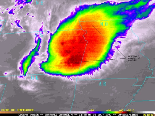
Mesoscale convective complexes (MCCs) —A particular type of MCS, an MCC is a large, circular, long-lived cluster of showers and thunderstorms identified by satellite. It often emerges out of other storm types during the late-night and early-morning hours. MCCs can cover an entire state. (N.O.A.A).
Picture 3. A Mesoscale Convective Complex (MCC) from satellite GOES – 8 on behalf of National Oceanic and Atmospheric Administration.
Mesoscale Convective Vortex (MCV)
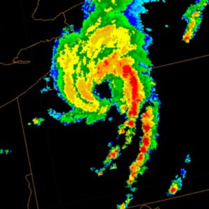
Mesoscale Convective Vortices (MCVs) are midtropospheric warm-core cyclonic circulations that often develop in the stratiform region of mesoscale convective systems. Typically, divergent, anticyclonically circulating, mesoscale cold anomalies appear both above and below the MCV. The upper-level cold anomaly is usually found near the tropopause while the low-level anomaly is surface based and exhibits locally higher pressure. One aspect of MCVs that has received much attention recently is the role that they may play in tropical cyclogenesis. Of special interest is how an MCV amplifies when deep convection redevelops within the borders of its midlevel cyclonic circulation and how the amplified MCV transforms the divergent surface-based cold pool with anomalously high surface pressure into a convergent cyclonic circulation with anomalously low pressure. (Robert F. Rogers and J. Michael Fritsch, 1, April 2001).
Picture 4. A mesoscale convective vortex over Pennsylvania with a trailing squall line.
Derecho
Derecho is a widespread and long-lived windstorm associated with a line of severe thunderstorms. It is characterized by straight-line winds that can exceed 58 miles per hour and can cause significant damage.
Derecho development is necessarily tied to the formation of bow echoes. A bow echo usually arises from a cluster of thunderstorms, but also may evolve from a single strong storm. Bow echoes most frequently occur when atmospheric winds are relatively strong and unidirectional (i.e., they vary little in direction with height but increase in speed). As the rain-cooled downdraft of a thunderstorm reaches the earth’s surface, it spreads horizontally, most rapidly in the direction of the mean atmospheric flow. (N.O.A.A).
Nikolaos Koulakis – Meteorologist & Weather Routing Analyst of Oceanroute

Privacy Settings
When you visit any web site, it may store or retrieve information on your browser, mostly in the form of cookies. Control your personal Cookie Services here.
These cookies are necessary for the website to function and cannot be switched off in our systems.
In order to use this website we use the following technically required cookies


